Public launch
StreetVision launched publicly in September 2025.
StreetVision · Road safety analytics · Zero-to-one product design
StreetVision helps state transportation departments and road-safety teams see where risky driving happens, such as speeding, hard braking, and phone distraction, so they can decide which roads need attention and measure whether changes work.
StreetVision grew out of a winning hackathon experiment on making geospatial driving data useful, and I was the designer on that team, turning the workflow they had in mind into something people could follow. About a year later, the company formed a Public Sector group to build it into a product. I joined as its founding and only designer and led design from first concept through public launch, working closely with product, engineering, and data science.
Results as reported by StreetVision. Read the announcement
01 · The opportunity
Most road-safety data starts with a crash. Crash records, traffic cameras, and field studies are essential, but they cover only part of the road network and arrive after something has gone wrong.
Telematics data can show driving behavior across an entire network: where people speed, brake hard, or use their phones, and when. The opportunity was to turn that data into a tool that people with very different expertise, from GIS specialists to safety officials, could use to find risk, plan improvements, and measure results.
02 · Direction
When the Public Sector team formed, I designed StreetVision's earliest visual direction, building on concepts from the hackathon: a guided flow where users answered plain-language questions about place, time, road type, and behavior before seeing their analysis. It gave product, engineering, and data science something concrete to react to from the start.
As we shared the clickable concept with state DOT staff, subject-matter experts, leadership, and data scientists, a clear pattern emerged. The guided questions worked best when we could predict what users wanted to explore, and real investigations rarely followed a set path.
I helped identify that and advocated for a map-first workspace with filters always at hand. The team shaped the new direction together, and I designed the interaction model that brought it to life.
The first concept
A guided flow of plain-language questions that set up each analysis step by step.
The direction we took
A map-first workspace with filters and analysis tools always at hand, so users could follow their own questions and move between analyses without starting over.
03 · Momentum
People could click through StreetVision long before it existed. Before engineering and data science were ready to build, I created a realistic, script-driven Figma prototype that helped stakeholders tell the product's story. Leadership and product owners took it to road-safety events, where it drove early interest and buy-in.
It also opened the door to users. After seeing the prototype at those events, staff from several state DOTs agreed to talk with us. With the PM at my side, I interviewed them, revised the design, and went back for more interviews until clear patterns emerged.
I shared what we learned with engineering and data science, and once they started building, I held regular working sessions with engineers to walk through designs and resolve questions.
04 · Workspace
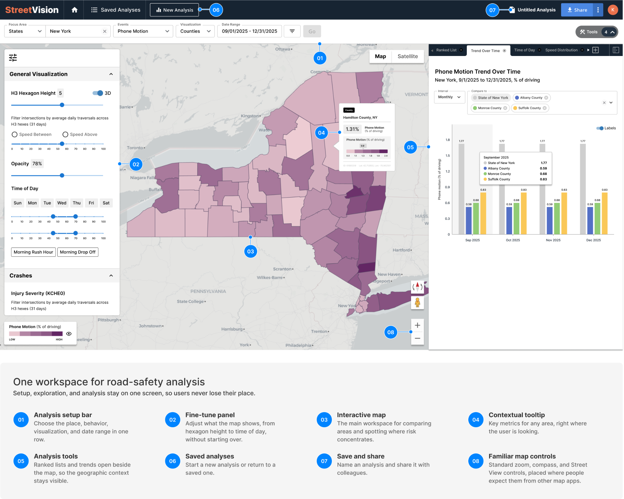
StreetVision's users ranged from newly trained transportation professionals to GIS specialists and data scientists. I organized the workspace around the questions road-safety teams actually ask: where risk is concentrated, what behavior drives it, and when it happens.
Essential actions stay visible, while advanced controls appear when an analysis needs more precision. A newly trained professional and a GIS specialist can open the same workspace, and each finds what they need.
05 · Impact
StreetVision launched publicly in September 2025.
Deployed by transportation departments in states from Massachusetts to Washington.
Urban Infrastructure Innovation, Smart Cities and Public Sector Tech category.
After a Flagstaff, Arizona intersection became a roundabout, StreetVision showed a 24.5% drop in hard braking and a 14% drop in phone distraction within weeks.
The reusable components I created remain the base for every new feature the team ships.
06 · Scale
As AI-assisted tools became part of everyday work, engineers, PMs, and data scientists on the StreetVision team began building their own proofs of concept on their local machines. Ideas were moving fast, and I wanted every one of them to look and work like StreetVision.
I designed modular interface tools anyone on the team could build with. The filters, tooltips, and fine-tune bar all draw from one shared set of components, like sliders, toggles, chips, and small charts, in light and dark mode. When a proof of concept was approved, its interface already met the product's standards, so it could move quickly into the product.
A way to add new filters to an already busy filter area, organized into clear sections, each with its own reset and options like additional time periods.
Used for filters like directionality, time of day, and day of week.
A modular tooltip that lets teams surface more detail about a road or area, from key metrics to small charts, and send it to the tool panel for deeper analysis.
Used for intersection details like speed distribution and time-of-day patterns.
A side panel of adjustable settings that update the map immediately as people change them.
Used for features like Speeding+ and the crash severity toggle.
For more complex workflows, I stayed available to work through the details with the team.
For new or complex workflows, I built proofs of concept myself. I ran StreetVision in a local development environment with real data, and presented the working concept at our regular PM, engineering, and design meetings for feedback. Once an idea was approved, I checked in my branch, and engineers started from a nearly complete feature they could validate and ship. It cut down the back-and-forth during implementation.
What I took away
Put something real in front of people early, and make it easy for others to do the same. The first guided concept, the clickable prototype, and the modular tools all gave people something concrete to react to and build on. Those reactions shaped the product's direction, opened doors with customers, and kept the whole team moving.
StreetVision was shaped by a talented team of product, engineering, data science, and road-safety experts. I'm grateful for what I learned from all of them.
Product visuals show StreetVision as publicly presented. Customer data has been removed or altered.
Continue the conversation
I'd be glad to walk through the design decisions, the prototype, and how the team worked together.